John McClure's 2300AD NearStar List
copyright 1997 by John McClure
A few years ago I had an idea for an
alternate way of showing distances in the 2300AD universe, one that I thought made more
intuitive sense to someone navigating through an arm. Basically, an XYZ view of a star
field gives a distorted view of distances that makes it hard to figure out how things lie
in relation to each other. So instead it makes sense that charts based on polar
coordinates would be used for the space around a star, where the radius is the actual
distance from the base star to the star in question. In the file, I have listed for each
star all of the other stars that fall at 7.7LY or less, and converted their location into
polar degrees, using the same longitude and latitude we have for Earth cartography.
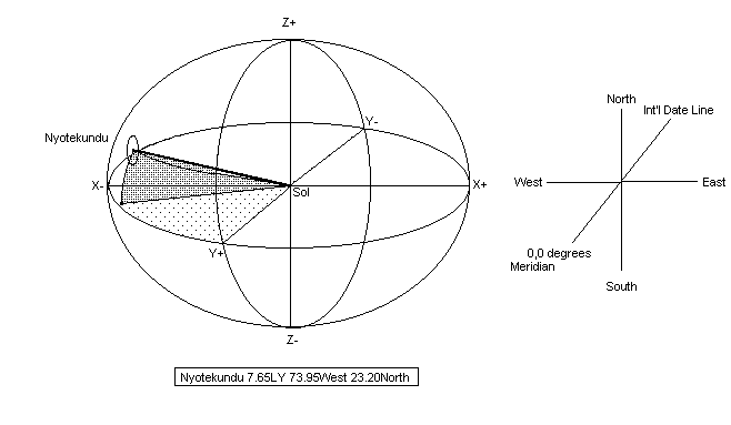
Example: You are at Sol and want to go
to Nyotekundu. You look at the chart for the listing for Sol, and you find the following
listing:
Nyotekundu 7.65LY 73.95West 23.20North
That tells you that you orient your
ship to 0,0 and turn 73.95 degrees west, 23.2 degrees north, and fly straight for 7.65LY.
What are 'North' and 'West' in space? Using the same base as the XYZ coordinates and an
Earth analogy: the Z 0 coordinate runs North/South through the poles, and the Y 0
coordinate runs from the meridian on the equator through to the international date line in
the Pacific. The X 0 coordinate runs from 90 East to 90 West on the equator.
Z+ is North, Z- is South. X+ is East,
X- is West. Y+ is Meridian, Y- is International Date Line.
in terms of organization of stars, the
further down the list, the further the star is from Sol.
- John McClure
Click
here for John McClure's NearStar File in Excel 5.0 format...
[ Back to the
2300AD Grand Game Support Page ]